Different perspectives on the Moon for Observe the Moon Night Sep 17, 2010
DREAM team members are providing additional perspectives on the Moon to assist observer for the upcoming InOMN on September 18 2010. LRO Participating Scientists Tim Stubbs and DREAM Collaborator Yongli Wang combine optical images and LRO Laser Altimeter data to provide a 3-D like perspective. The predictions are designed for the Moon phase set for September 18, 2010 at 9:00pm EDT (September 19, 2010 at 1:00am GMT).

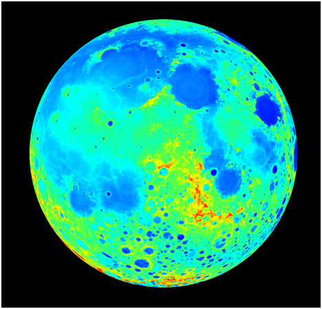
Fig 1. A map of lunar topography, or surface height, as it would appear if viewed from the Earth on InOMN (orthographic projection). The surface heights are measured relative to a reference distance of 1737.4 km from the Moon's center, which is the lunar equivalent of sea level on the Earth. On this map, surface heights range from 6 km above (dark red) to 6 km below (dark blue) this reference distance (green is zero). This map makes it easy to pick out high mountains and the low seas (or maria). The data used to produce this map was acquired by the Lunar Orbiter Laser Altimeter (LOLA) onboard NASA's Lunar Reconnaissance Orbiter (LRO).

Fig 2. The Moon as it will "roughly" appear in the sky during InOMN. This lunar "appearance" map was produced by combining geometrical reflectance predictions, calculated using the topographic map, and a surface "albedo" map in the near-infrared. (Albedo is a measure of surface reflectivity; i.e., how light or dark it appears). Since we have had to use a near-infrared albedo map, the Moon will appear slightly different in visible light.

Fig 3. A map showing the amount of sunlight predicted to reach the surface of the Moon during InOMN. These predictions were produced using the topographic map, and have been overlaid on the lunar appearance map in order to help provide some context. High sun is indicated by dark red, low sun by dark blue, and, of course, no sun by black.

Fig 4. A map of "shadow depth" on the night side of the Moon during InOMN. Here, shadow depth refers to the shortest distance to the sunlight/shadow boundary above the surface. These predictions were also produced using the topographic map, and have been placed next to the lunar appearance map in order to provide some context. In this case, shadow depths, as viewed from the Earth, are expected to range from 0 km (dark red) to 450 km (dark blue). On InOMN, it will be the dawn terminator that is visible from Earth, and so the surface in shadow will be approaching sunrise. ("Terminator" refers to the boundary between day and night, i.e., sunrise and sunset, on a planetary body.)

Fig 5. The location of the Moon relative to the Earth on InOMN. The left panel shows the view from above the north pole, and the right panel shows the view toward dusk. The gray line is the Moon's orbit for about two weeks either side of InOMN. The Earth and Moon are not shown to scale: the Earth has been made five times larger, and the Moon ten times larger.
Also shown are typical locations for the magnetopause and bow shock. The magnetopause marks the outer boundary of the magnetosphere - the region where the Earth's magnetic field dominates the local space plasma environment. The bow shock is formed by the supersonic solar wind as it flows around the magnetosphere. The Moon is exposed to a wide range of space plasma and radiation conditions, which can have significant effects on the lunar environment see link. During InOMN, the Moon is expected to be immersed in the shocked plasma of the magnetosheath region between the magnetopause and bow shock.
Credits: Tim Stubbs, Yongli Wang, LRO/LOLA, NLSI/DREAM.
Back to DREAM Homepage

